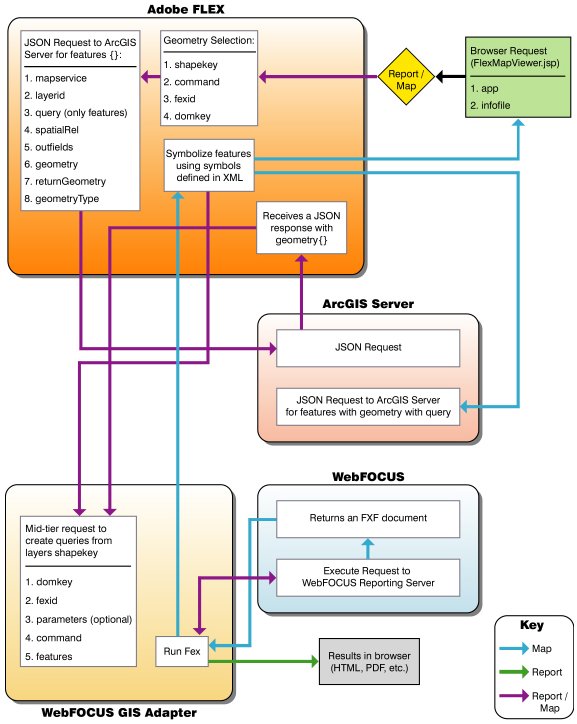
Architecture of a Geographic Business Intelligence Solution
This section outlines the key components that are combined
to form the architecture of a Geographic Business Intelligence Solution
(GBIS). These key components include:
- Adobe Flex (Client)
- WebFOCUS Adapter for Geographic Information Systems (Middle
Tier)
- ArcGIS Server
- WebFOCUS Reporting Server
x
For this Geographic Business Intelligence Solution (GBIS),
Adobe Flex is used as the client. Adobe Flex is an open source framework
used to develop rich Internet applications. When a user issues a
request using a web browser, this request is passed to Adobe Flex
to create a selection request for the ArcGIS Server. Adobe Flex
is also used to process responses from the ArcGIS Server to pass
to the middle tier. All symbol generating and map rendering processes
occur in this framework.
xWebFOCUS Adapter for Geographic Information Systems (Middle Tier)
WebFOCUS Adapter for Geographic Information Systems
is the middle tier (gateway) to issue requests to the WebFOCUS Reporting
Server and receive responses from the Reporting Server. All responses
from the WebFOCUS Reporting Server are processed to the web or to
the client.
x
ArcGIS Server is a Geographic Information System (GIS)
software package developed by ESRI that is used to deploy web-oriented
spatial data services. It allows users to publish maps on to the
web. ArcGIS Server processes any user selections that are made on
the map. The map consists of various data layers for the corresponding
perspectives that are being used (for example, streets, neighborhoods,
arrests, and so on). Based on the location of these layers, ArcGIS
Server performs spatial filtering and returns a response to the
Client. The response is formatted as JSON formatted text. As a result,
the Client uses this JSON formatted text to make further requests.
For more information on ArcGIS Server, visit the following website:
http://resources.arcgis.com/en/help/getting-started/articles/026n00000007000000.htm
xWebFOCUS Reporting Server
The WebFOCUS Reporting Server is the Reporting Server
used by WebFOCUS. WebFOCUS reports are triggered using a location-based
query, which is passed to the WebFOCUS Reporting Server and then
served as stylized reports.
WebFOCUS is the most secure and flexible business intelligence
solution meeting all the reporting needs of the extended enterprise,
ranging from analysts, to power users, and to the widest deployments
for hundreds of thousands of users. The empowerment provided by
WebFOCUS for organizations seeking to leverage all their data by
accessing it all, from legacy to data warehouse, is unmatched.
x
The diagram in this section illustrates the workflow
between the key components that are combined to form the architecture
of a Geographic Business Intelligence Solution (GBIS). The line
connectors between the components can be uni-directional or bi-directional.
In addition, the function calls for the middle tier are clearly stated.