The common J2EE architecture of the GBIS enables developers
to easily add a GIS component to business intelligence applications
using a set of Java™ APIs. The J2EE architecture also ensures the
scalability needed to deliver GBIS reports throughout the extended
enterprise without a significant increase in hardware spending.
x
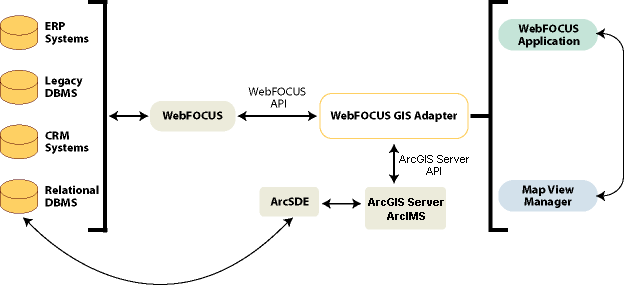
ArcIMS provides the foundation for distributing high-end
geographic information systems (GIS) and mapping services using
the Internet. ArcIMS software enables users to integrate local data
sources with Internet data sources for display, query, and analysis
in an easy-to-use web browser.
Specifically built to serve GIS on the Internet, ArcIMS is designed
to make it easy to create map services, develop webpages for communicating
with the map services, and administer sites. ArcIMS operates in
a distributed environment that consists of both client-side and
server-side components. Typically, the client requests information
from an Internet or Intranet server. Then the server processes the
request and sends the information or map back to the client viewer.
x
ArcSDE is a gateway that facilitates managing spatial
data in a database management system. ArcSDE allows you to manage
geographic information in one of four commercial databases:
- IBM DB2
- IBM Informix
- Microsoft SQL
Server
- Oracle
ArcSDE serves spatial data through ArcGIS Server, as well as
other applications and it is the key component in managing a multi-user
spatial database.
x
WebFOCUS is the most secure and flexible business intelligence
solution meeting all the reporting needs of the extended enterprise,
ranging from analysts, to power users, and to the widest deployments
for hundreds of thousands of users. The empowerment provided by
WebFOCUS for organizations seeking to leverage all their data by accessing
it all, from legacy to data warehouse, is unmatched.
x
The WebFOCUS GIS Adapter is a servlet-based, server-to-server
interface that allows parameters to pass between the application,
WebFOCUS, ArcGIS Server, and ArcIMS. The WebFOCUS GIS adapter allows
us to select areas of a map, capture the data underlying this selection,
and present it as a WebFOCUS report. It also allows for data displayed
in all the wonderful ways WebFOCUS presents information to be represented
on a map.
This ability which presents bidirectional integration between
business intelligence and GIS is unique in the industry. Up until
now, GIS analysis has been limited to power users. These are users
who are technical enough to understand complex applications, and manipulate
and transfer data files. Also, other BI interfaces have been based
on a client/server model.
End users view new mapping functions as part of their existing
application with little-to-no additional training. Analysts and
power users can toggle between a map and business intelligence application,
easily passing results and sharing information. This integration
is completely seamless. Existing users of either WebFOCUS or ESRI
software will benefit immediately and require no retraining to use
these features.