In this section: |
The Settings tab allows you to configure display information settings, window display settings, and miscellaneous settings.
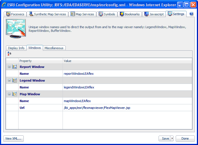
The display information settings allow you to customize map display and layout properties. To configure display information settings, click the Display Info tab in the Settings pane.
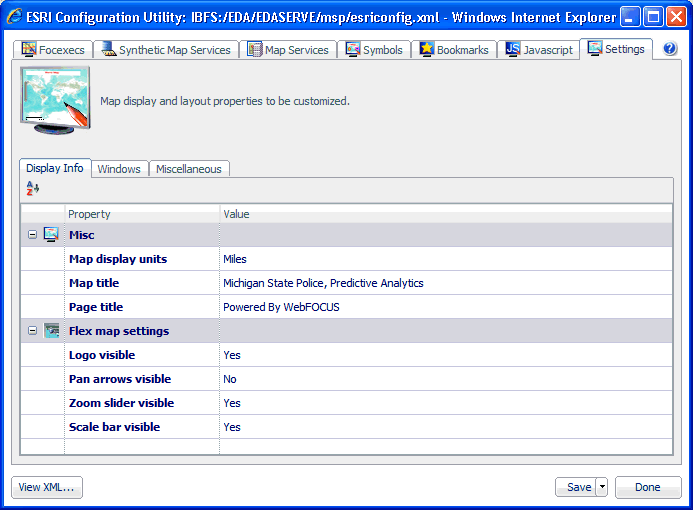
The following table lists and describes the configuration properties that are available in the Display Info tab.
Property |
Description |
---|---|
Misc | |
Map display units |
Allows you to set the display units that will be used by the map. Select one of the following units from the drop-down list:
|
Map title |
The title of the map to be displayed in the WebFOCUS GIS Viewer for Flex. |
Page title |
The title of the page to be displayed in the web browser window. |
Flex map settings | |
Logo visible |
Determines whether to display the ESRI logo. Select true or false. |
Pan arrows visible |
Determines whether to display the pan arrows to drag the map. Select true or false. |
Zoom slider visible |
Determines whether to display the zoom navigation toolbar. Select true or false. |
Scale bar visible |
Determines whether to display the scale bar on the map. Select true or false. |
The window settings allow you to customize the windows (LegendWindow, MapWindow, ReportWindow, and BufferWindow) that are used to direct the output to and from the WebFOCUS GIS Viewer for Flex. To configure window settings, click the Windows tab in the Settings pane.
The following table lists and describes the configuration properties that are available in the Windows tab.
Property |
Description |
---|---|
Report Window | |
Name |
A unique name to identify where the results from a report FOCEXEC are targeted. |
Legend Window | |
Name |
A unique name to identify the legend window that is displayed. |
Map Window | |
Name |
A unique name to identify where the map is going to be painted. |
Url |
The URL used to display the map (required). For Flex the value should be: /ibi_apps/esri/flexmapviewer/FlexMapViewer.jsp The ESRI Configuration Utility automatically adds the URL. |
The miscellaneous settings consist of application settings that can be used to configure map viewer performance. To configure miscellaneous settings, click the Miscellaneous tab in the Settings pane.
The following table lists and describes the configuration properties that are available in the Miscellaneous tab.
Property |
Description |
---|---|
Application path |
The path to the application folder on the server. |
Error Page |
The path to the HTML error page. |
Callback | |
Identify |
The JavaScript function that is used after running an Identify FOCEXEC. |
Map |
The JavaScript function that is used after running a Map FOCEXEC. |
Report |
The JavaScript function that is used after running a Report FOCEXEC. |
Map init |
The JavaScript function that is used before painting the map. |
Report init |
The JavaScript function that is used before running a report. |
Rollover callback |
The JavaScript function that is used when performing a rollover (contextual). |
Performance | |
Append to fex prompt |
Add .fex extension to FOCEXECs. Boolean value. |
Cache DOM |
Store JavaScript in DOM. Boolean value. |
Cache filter |
Stores the filter in memory. Boolean value. |
Cache JavaScript |
Stores the JavaScript in memory. Boolean value. |
Check ESC |
Checks for the escape character. Boolean value. |
Enable debug window |
Opens a window for debugging. Boolean value. |
Filter format |
Specifies the format to be used for filtering. |
Focus temp |
Specifies the storing format for FOCUS. The default value is TXT. |
FTM | |
Image file type |
Specifies the image file type to be used. The default value is png. |
Image redirect |
Determines if an image redirect should be applied. Boolean value. |
Map cache depth |
The number of maps in memory. Increase this value for report to map drill-downs. |
Max feature items |
The maximum number of features to be returned after queries. |
Max length image line |
The maximum length of an image line. |
WebFOCUS |